Property maps of assessable vegetation (PMAVs) are the mechanism for correcting vegetation maps with NRM.
What is a property-scale PMAV?
A property-scale PMAV (property map of assessable vegetation) maps the vegetation on your property at a property scale – usually around 1:25,000.
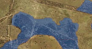
Current vegetation mapping on a property is at 1:100,000, which results in many areas of country being incorrectly mapped as Category B (virgin vegetation), as seen below (blue area is mapped as remnant vegetation):
A property-scale PMAV can correct these errors, which can allow substantially more areas of property to be mapped as Category X (cleared), which can then be legally cleared under the vegetation management framework. Most current PMAVs are a ‘lock-it-in’ type of PMAV, which simply locks in all the vegetation as Category X at the date the PMAV was submitted.
What if I already have a PMAV?
The property scale PMAV will replace your existing PMAV, locking in more areas of Category X (white) on your property. You cannot lose areas in a PMAV change. All areas that are currently mapped as white will continue to remain as Category X when a PMAV is updated.
What is the legal requirements?
Legally you cannot clear any regrowth vegetation unless it is mapped as Category X on a PMAV. Any clearing of vegetation that is Category B on a PMAV can result in a compliance action from NRM. So it is important to get a property-scale PMAV certified prior to any clearing activities.
How can Ecosure help?
Ecosure has developed mapping systems with detailed imagery to correct PMAVs without the requirements of field work. This allows us produce the relevant reports and data without the need of field work, therefore keeping costs to a minimum. We can also help with correcting mapping errors on PMAVs. This can either be done with a site visit, or by supplying photographs and GPS coordinates of areas that need fixing.
Further details on PMAVs are available here
Contact: Paul Humphreys or Geoffrey Sinclair in our Rockhampton Office on 07 4994 1000.


